


Mt Kilimanjaro was Fun
Mt Kilimanjaro
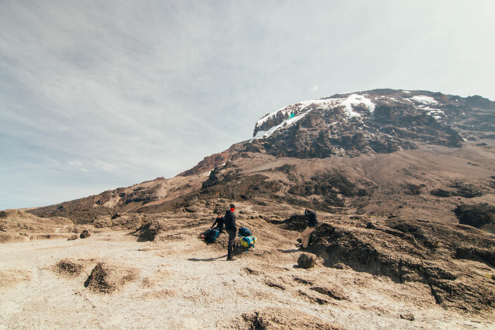
Mt Kilimanjaro has been on the radar for a while and Africa’s highest peak was something I was rather keen to beat my brother to the top of. So on December 1st last year I finally booked flights to give it a crack.
It had been a total of 24 hours flying and 9 hours airport bound in Doha before I finally saw the peak from the window of the 787-9 on approach into Kilimanjaro International Airport. Needless to say I was pretty darn excited. I had my fingers crossed that my “training” regiment would be enough (this included 2 weeks snowboarding/drinking/feasting in Japan only 14 days prior). To be fair, I think my body is fairly well conditioned for long distances with a heavy pack but not at the altitudes that I knew we were about to experience.
The following few paragraphs is a collection of thoughts and experiences most of which I tried to write on the mountain after we were finished trekking for the day. I've also included the height and distance statistics from my fitness tracker which I wore the whole way up.

Day 1
It’s a long dusty road from our lodge to the start point of Lemosho Gate. Our driver seems to be hell bent on passing every bedraggled Hiace and multicoloured truck on the road in front of us. Our van is packed full of young and lively looking Tanzanian lads chatting away in Swahili and then there is me and Amy wondering what we have got our selves into.
After about a 4 hour drive with a couple of stops on the way for food and paperwork. Our Tanzanian Hiace rally champ driver drops us at a car park in the jungle gives us a bro shake and then departs with a hiss and a roar back down the dirt road we came from. Once the dust cloud had cleared we get introduced to our new family of 2 guides a cook and a few porters and start our journey into the jungle that makes up the lower slopes of Mt Kilimanjaro.
Our guides are Isaac and Abu and both are great company as we wind our way ever upwards through the lush green mountain jungle. As we walk we are treated to Colobus and Blue monkeys bounding through the trees who seem rather bored with yet another group of humans wandering through their patch of jungle.
After a 2 hour hike we arrive at our first campsite seemingly too quickly but exhausted all the same (mostly due to gripping the seat on our van ride in). Dinner is quickly followed by bed and a friendly warning not to sleep past 6 or wander into the jungle alone for a toilet break.
Day 1 Stats
Lemosho Gate = 2000m
Big Tree Camp = 2700m
6km hiked over 2 hours
660 Vertical Metres climbed


Day 2
We were warned that day 2 was the tough one on our chosen route and it did not disappoint.
A 0600 wake up followed by a quick breakfast of porridge and fruit preceded us tramping off into the jungle to leave the porters to pack up the tents. Not quite sure how to feel about leaving them to do the work but our guides assured us thats why they were there and we would be grateful come this evening.
The tramp started with an uphill trail leading through the ever dwindling jungle until we reached the level where the trees could no longer grow and gave way to shoulder height alpine shrubbery. We climbed and we climbed and we climbed until the sweat coursed in rivers down our faces. The sun made me regret forgetting to sunblock almost instantly as my neck started to burn with a mix of sweat and sun. We dutifully plodded on until Isaac assured us we were nearly at the midway point of Shira 1 camp where we would finally see the summit and could stop for lunch.
1400 vertical meters after we started in the jungle below we reached Shira 1 camp and got our first view of Kilimanjaros Volcanic cone framed with blue sky and light winds. What a sight it was! It was such a view that we nearly forgot about the sweat mixed with jungle dirt concoction that plastered us head to toe. Nearly.
After about a 45 minute sit down involving a hot lunch put together by our cooks we started the 2nd half of the day aiming to reach Shira 2 for dinner. Shira 2 camp is at an altitude of 3900m which would be the highest either of us had gone human powered and our first taste of proper altitude.
We were assured that the leg from Shira 1 to Shira 2 was mostly flat and mostly flat it was, but after a hot and hefty climb that morning neither of us was feeling too flash and the leg seemed to drag forever. I think it was around 11km and about 300 vertical metres but it felt like a lot longer and steeper.
Toward the end of the leg with the final camp in sight I started feeling either the altitude or the length of the day or the sunburn or possibly a mixture of all three and the over-exertion headache came out in force.
Nevertheless, we made it to Shira 2 and after a quick dinner which neither of us really felt like we collapsed into the tent that the aforementioned porters had already erected for us (we now understood why they were there)
Day 2 Stats
Big Tree Camp = 2700m
Shira 2 Camp = 3900m
19km hiked over 7 hours
1770 Vertical Metres climbed


Day 3
We were awarded a sleep in and leisurely start to Day 3 after our massive Day 2. So up at 0630 with breakfast and prep leading us to a 0830 start. Today was an acclimatisation hike with an ascent up to 4600m (roughly 14000ft which stuck out to me as in our unpressurised Cessnas we are not allowed above 13500ft in any circumstances due to oxygen depravation) and then back down to camp at 3900m again.
The attraction at 4600m was a monstrous lava tower left by old eruptions millions of years ago. To get to it we hiked through alpine desert almost from the get go with only the occasional shrub or tussock to show there was life left this high up.
We definitely started to feel the altitude today as what would be an easy 700m vertical at home took its toll. Everything seemed to take more effort and even taking a drink from the bladder left you needing to catch your breath.
After about a 3 hour slow trek to the lava tower, we stopped for snacks and to my surprise I was feeling pretty good. Amy unfortunately seemed to have developed the headache that I had had the day before. The lava tower itself looked a daunting sight but we were rather pleased to see it as it meant the descent back to camp was shortly to start.
As we ate and rested and tried to get used to the altitude we were kept company by zebra mice who obviously knew that trekkers came past and that scraps of food might be available.
After an hours break we started the descent to Baranco Camp which was to be our overnight. The hike down took us through some amazing scenery with massive cacti/cabbage tree type things lining the path down.
On arriving at Baranco Camp we were greeted by swirling clouds and a stiff breeze which I quite welcomed, anything to get rid of the sun. Our support team had not come up to the lava tower with us instead taking a low path to arrive at Baranco well before us and mercifully had warm water and hot food ready for a wash and a feed.
Day 3 Stats
Shira 2 Camp = 3900m
Lava Tower = 4640m
Baranco Camp = 3950m
14.5km hiked over 6.5 hours
1019 Vertical Metres climbed


Day 4
We woke up on Day 4 and once again we’re greeted by hot porridge toast and fruit and then given a couple of options by Abu.
He seemed to think we were doing pretty well and could probably do 2 days worth of hiking today to cut down on our time on the mountain and at altitude by a night. We thought heck why not and so started our double day by tackling the Baranco Wall.
The Baranco wall was my favourite part of the trek so far. 400m of near vertical rock face that we zigzagged our way up picking past porters and scrambling around rocks climbing upwards out of the shadow of the valley we had camped in. The top of the wall was at around 4300m. When we finally topped it we were greeted by endless views of Tanzania below and a stunning view of the summit we had yet to tackle.
After a brief snack break we made our way over lunar landscapes down and sideways to Karanga Camp which took around 2 hours. We arrived just in time for a hot lunch prepared by our ever cheerful chef who once again had arrived early with the porters.
This was originally planned to be the end of our 4th day so below are the stats to halfway;
Baranco Camp = 3900m
Top of Baranco Wall = 4400m
Karanga Camp = 3950m
7km hiked over 3 hours
550 Vertical Metres climbed
At around 1300 we were all feeling chipper so we started on part 2 of our day the climb up to Barafu Camp which also served as base camp for the summit.
The hike from Karanga was a relatively slow climb through alpine desert up to 4675m. The landscape was quite Martian and it was easy going for the most part.
After about 2 hours we could see base camp and we were both stoked we had done the last section so quickly! Our elation was quick to burst however as we topped a ridge and saw the last section of the day. The track fell away almost vertically into a valley just before camp and then rose steeply back up to the rangers hut we had seen just moments before.
Great.
After about an hour of sweating we managed it though and arrived at Base Camp to see our tent already up and wedged between 2 boulders the size of minis. Abu then gave us a brief about the state of affairs for our push to the summit. It would be a 0100 wake up call with a 0200 start and aiming to be on the crater rim for sunrise.
Roughly 1300m of elevation at altitude in the middle of the night.
How good.
Day 4.5 stats
Karanga Camp = 3950m
Barafu Camp = 4675m
6.5km hiked over 3 hours
655 Vertical Metres climbed
Day 4 Total stats
Baranco Camp = 3900m
Barafu Camp = 4675m
13.5km hiked over 6 hours
1205 Vertical Metres climbed


Day 5
This morning we were gunning for the summit so it was 0100 when one of the porters greeted us from outside the tent.
We stumbled out from in between our boulders and pulled on all the warm gear we could find (mostly Sons Merino of course) then after a ginger tea and a couple of biscuits we started the long climb in the dark to the summit.
Barafu Camp is 4675m and the summit (Uhuru Peak) was at 5895m so we had a good 1300m to climb at altitudes that we hadn’t yet experienced.
Most of the climb up was a blur of snow showers, headlamps in the eyes and one foot after the other. We could definitely feel the altitude with my stomach doing backflips and Amy’s headaches back again.
At points it felt like we had covered quite a lot of ground but as I peered up into the darkness I could still make out the headlamps of other climbers what seemed like miles ahead. We also had a couple of distressed looking groups come down as we were climbing who Abu said had not been able to cope with the altitude. Great motivation for us.
It started getting light around the time that Abu and Isaac assured us we had passed through 5500m and had only 400 vertical metres to go. As we kept looking up into the snow showers it was hard to believe as the mountain just kept stretching up into the clouds.
After what seemed like a day (actually about 5 hours) we finally had Stella Point (The crater rim) in sight and pushed hard to reach it and possibly have a snack and a break.
As we climbed over the crater rim and finally felt like we didn’t have to climb anymore we were hit by a gust of snow and ice that nearly toppled us and our guides.
No respite.
The last part of the trek was about a 40 minute walk around the crater rim to the highest point on the mountain Uhuru Peak. On a nice day it would be a pleasant stroll taking in the views and enjoying the sunrise. For us it was a wild scramble sideways through blizzard conditions with freezing fingers and iced over sunglasses. Not exactly what we had pictured.
More than once I wondered if our guides actually knew where we were going. We saw about 3 other groups of wind lashed climbers coming back from the general direction of the summit so I assumed we were going in the right direction. After again what seemed like forever in the sideways snow storm we saw the famous sign that marked the peak.
Hallelujah.
We huddled down and took a few quick pictures before deciding to get the hell off the wind blasted peak and bee-lined our way back to the shelter of the leeward side of the mountain. Not quite the summit experienced we had envisioned. It felt like the mountain did not want us there but we had made it all the same. Take that Kilimanjaro.
After finally being able to stop and take a rest we started our descent back down to Base Camp. In the 6 hours we had taken to climb to the top about 25cm of snow had fallen onto the scree slopes which gave the way down a completely different feel to the rest of our trek.
On arriving at Base Camp again around 1100 we were greeted by snowy tents and congratulated by the team. We had done it. We were told we could have a quick snooze and lunch would be ready at 1300 after which we had a 2 hour hike down to millennium camp at 3900m.
1300 came pretty quickly and neither of us wanted to get out of our sleeping bags after a 9 hour hike already. But we somehow did and followed our hot lunch with the first downhill leg of the trek so far.
2 hours passed by pretty quickly in the state we were in and we mercifully arrived at millennium camp to tents already set up and pretty well collapsed into the best sleep we had since leaving 5 days ago.
Day 5 Stats
Barafu Camp = 4675m
Uhuru Peak = 5895m
Millennium Camp = 3900m
19km hiked over 11 hours
1301 Vertical Metres climbed


Day 6
Our last morning on the mountain was the smoothest yet we were up and ready and breakfasted before our guides and raring to get started on our downhill leg and last leg on Mt Kilimanjaro.
The hike down started quite steeply and almost immediately my knees started to complain. The left more than the right as usual. The scenery was amazing though and we saw monkeys, safari ants and Amy even found me a little chameleon crawling away into the undergrowth. The views were spectacular too and we could make out towns and farms and lakes below us and out to the horizon.
After 4 hours, 10km and 2000 vertical metres of knee torturing downhill we came out onto what looked to be the access road. Abu and Isaac assured us it was AN access road but not THE access road. Drats. Only another 45 minutes though they said and we would be at our exit Mweka Gate.
We finally reached the finish line with swollen hands and sweaty backs and collected our certificates proclaiming we had climbed Africa’s highest mountain.
Stoked.
The driver that had dropped us off was there to collect us in the same beat up Hiace and after packing all the gear onto the roof we made the 30 minute drive back to our lodge. Once there we completed the formalities, brought all the boys a beer and celebrated briefly before waving goodbye to the team that had made the mountain possible. Quickly after that we were in the shower and pool washing away 6 days worth of grime and trying to collect our thoughts on the week we had just spent.
Day 6 Stats
Millennium Camp = 3900m
Mweka Gate = 1650m
14km hiked over 5 hours


Mt Kilimanjaro was probably one of the toughest treks I have completed mentally and physically. The altitude made it pretty rough going and the kms day after day definitely didn’t help. But with the help of our Tanzanian Team it was a fantastic experience and i would recommend it to anyone with even half a mind to try it.
Overall Stats
5955m Vertical Meters Climbed
86km Hiked over 6 Days
If anyone has any questions about any of it email/DM/holla at me on the usual channels thanks for reading!
Mark.


Leave a comment